Because of the rugged, inhospitable terrain, this area is one of the most inaccessible on earth. Vast distances limit access to those travelling by dog sled or bush plane. Rugged topography limits travel within the area to mountaineers with technical climbing skills. Scores of unclimbed peaks exist.
The area is home to several noted mountain peaks:
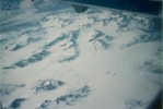
By every measure except altitude, the range is truly enormous. It extends for some 700 miles from the Yukon border to the Chukchi Sea, on Alaska's west coast, near Cape Lisburne. In most places it is 80 to 110 miles wide. Its great horizontal extent separates two of Alaska's major climatic zones: the interior and the North Slope.
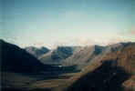
The scenery in the Brooks Range is most spectacular. It is a complex maze of canyons whose bottoms are usually flat with meandering and/or braided rivers and many lakes and meadows. The divides between the canyons are sometimes sheer rock walls and sometimes mellow, undulating ridges. The only road access into the range is via the Dalton Highway which transects the range on its way from Fairbanks to Prudhoe Bay on the shore of the Arctic Ocean. Only a narrow corridor of the range within hiking distance of the road can be reached via this access. The remaining 95% of the range's area is accessible only by airplane. In the summer the Brooks Range supports trekking, hunting, and river running. In early spring when the rivers are still frozen, cross-country skiing is popular.
North Slope
The North Slope is the region of Alaska north of the Brooks Range. It is treeless, as the growing season will
only support tundra. It is mostly flat, with a few scattered undulations
due to the freezing and thawing of the ground above the permafrost. Most of
the hills in this region are therefore, in effect, frost heaves. The area
is all but unpopulated by humans. Herds of caribou roam the area in the
summer.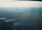
Although the area is technically a desert, receiving about 5 inches of moisture per year, few would tend to think so because of its many lakes and rivers and its extensive (non-tree) vegetation. Biogeographers have termed this type of region a "cold desert". The small quantities of water that do fall on the area as precipitation are very slow to evaporate. Much of it soaks into the ground, where it freezes the following winter. The flatness of the area results in poor drainage, hence the many thousands of lakes that cover some parts of the region. Furthermore, the North Slope is underlain by shallow bedrock, which aids in retaining groundwater.
Most of the North Slope has short mild summers, except for a few Arctic Coastal areas where the temperature rarely exceeds 40° Fahrenheit. All other seasons are brutally cold throughout the region.
The native Athabascans called the mountain Denali, which means, very simply,
"the great one" or "the high one". The Russians called it Bolshaya, which
has a very similar meaning. It received its present name from William H.
Dickey, a reporter for the New York Sun, who made a trip to Alaska in 1896
to report on the gold rush which was getting under way. While on the trip,
he got into an argument with a prospector about the gold standard, which the
prospector opposed but Dickey favored. As a way of getting in the last
word, Dickey referred to the mountain as Mount McKinley, for William
McKinley, then a candidate for President of the United States, who also
favored the gold standard. Because of the number of people who read his
writing in the Sun, that was the name that stuck. Most climbers and other
people familiar with Alaskan history and culture strongly prefer to call it
Denali regardless of what Congress decrees. Denali is a highly appropriate
reflection of the mountain's stature, whereas William McKinley never
travelled to Alaska and is not known to have had any interest in the
mountain. Some are even offended by the mountain's present official
name.
At low tide, miles of mud flats become exposed; if it were not for the
occasional quicksand and possibility of tidal bores when the tide comes back
in, it would be safe to walk across the entire width of the channel in some
places. One would think that Turnagain Arm would be very deep because it is
surrounded by mountains. However, the heavily silt-laden glacial streams
drop their loads when they flow out into the calmer waters of the sea.
Over the eons the silt accumulates into a mud flat which is exposed at low
tide.
For about 20 years the valley lived up to its name. Then the ash cooled,
and the flow of liquid water on the surface resumed its inexorable work.
Today the Valley is mostly a barren, light peach- to salmon-colored crust of
porous, spongy, brittle rock and sand. The surface is mostly flat, except
where the Valley's three main rivers have eroded canyons up to 100 feet
deep. The canyons are still eroding at the rate of 1½ feet per year.
A small minority of geologists argue that this erosion rate is impossible;
a 100-foot-deep canyon cannot possibly be eroded from a flat uneroded
virgin surface in 70 years, and that the present-day valley floor did not
come from the 1912 eruption. But the orthodox interpretation of the
observations is that such an occurrence, although incredible, is true.
For about 40 years it was believed that Mount Katmai itself, not Noavrupta,
had erupted. Then it was shown that the present-day caldera on Mount Katmai
(along with its lake which is very much like Crater Lake in Oregon) formed
in a collapse of the summit into the void left behind by the Novarupta
eruption.
This website is the recipient of a
Study Web Academic Excellence
Award.Denali (Mount McKinley)
Mount McKinley, the official name of what the native Athabascans called
Denali, is Alaska's best known landmark. At 20,320 feet above sea level, it
is the highest peak in North America and the northernmost peak that reaches
over 20,000 feet. Although not quite as high in altitude as the major peaks
of the Andes or Himalayas, the mountain is considered a world-class climb.
Its combination of high altitude and high latitude makes it one of the
coldest places on earth. Climatically, Mount McKinley is the highest
mountain in the world outside of Antarctica; the summit of Mount Everest is
climatically equivalent to the 13,000 foot level on Denali. With 18,000
feet, Denali also has more vertical relief than any other mountain in the
world.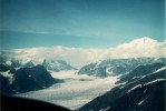
Cook Inlet, Knik Arm, and Turnagain Arm
Cook Inlet extends north and then east from the Gulf of Alaska. It divides
into two arms: Knik Arm on the north and Turnagain Arm on the south, with
Anchorage on the peninsula between the two. Cook Inlet and its two arms are
noted for their tides. With 30 to 35 feet between the high and low tides,
the Inlet has the second largest range in the world after the Bay of Fundy
in Nova Scotia. The reason for this enormous tidal range is the same in
Cook Inlet as in the Bay of Fundy: the length of the bay is such that the
resonant frequency of the water sloshing back and forth in it is close to
12 hours, which is the frequency at which tidal forces from the moon and sun
are driving it. Cook inlet is also noted for its tidal bores, which are
like breaking waves rushing upchannel when the tide comes in. They are due
to the fact that much of the inlet is too shallow to support normal flow of
water when the tide comes in. Cook Inlet is the only place in North America
where tidal bores are frequently observed. When Captain Cook explored
Turnagain Arm, he observed the tidal bores, recognized the danger, and told
his crew to head back out to sea. That's how Turnagain Arm got its name.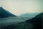
Valley of the Ten Thousand Smokes
In 1912, Novarupta, a vent on the side of Mount Katmai, erupted and sent a
mass of hot ash rushing down a valley stream. When the material finally
stopped moving, the valley was buried under this hot ash to depths up to 700
feet. The explosion was heard in Vancouver, British Columbia, some 1400
miles away. On nearby Kodiak Island it was as dark as night and visibility
was reduced to inches. In 1916, Robert Griggs, a botanist at the National
Geographic Society, became the first to set foot on the now stark and barren
landscape. The hot material had vaporized the water running through the
former valley floor as well as rainwater and spring water flowing into it
later, creating hundreds or thousands of plumes of steam belching from
fumaroles. Griggs then named it the "Valley of the Ten Thousand Smokes".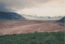
 Back to
the main Alaska trip page
Back to
the main Alaska trip page