Alpine Air is located not in Anchorage, but in Girdwood, which is about a 45
minute drive southeast toward Seward, where I was headed anyway. This
scenic drive features views of Turnagain
Arm, the southern branch of Cook Inlet,
on which Anchorage is situated. Mountains on both side of the inlet rise
straight up out of the water. There are many scenic viewpoint car pullouts
along the roadside. The drive is much like California's Pacific Coast
Highway, but better because there are mountains on both sides of the
channel. Turnagain Arm is noted for its
tides because of their enormous range (30 to 35 feet), tidal bores, and
miles of mud flats which are exposed at low tide.
The Chugach Range
After an uneventful night in a rented Ford Escort near Anchorage, I headed
back to Merrill Field, Anchorage's general aviation airport. Merrill field
is home to Vernair, on which I planned to take a flightseeing tour of the
Columbia Glacier, a vast 440-square-mile ice sheet that flows into Prince
William Sound. There was not yet anyone else wanting to go on the same tour
at the same time, and Vernair is reluctant to make a trip with only one
paying passenger, so I had breakfast across the street while waiting for
someone else to call with the same interest. That didn't happen, and I
didn't want to wait forever for something that might not happen within my
planned time near Anchorage, so I decided to contact other carriers in case
one of them could give better results. I called Take Flight Alaska (from
whom, by coincidence, I had considered renting an aircraft to fly myself on
part of this trip); their situation was the same as Vernair, with no one
else interested in the same tour but they took my name in case they could
combine me with someone else. I later discovered in a newspaper ad an
outfit named Alpine Air, called them, and this time scored a partial hit.
They had a couple wanting to see not the Columbia Glacier itself, but some
other nearer glaciers in the Chugach Range with an add-on to Prince William
Sound. I decided that this would be satisfactory should my original plan
not materialize. After one more call to each of Take Flight and Vernair to
see if either of these operators had another Columbia Glacier taker and
finding none, I cancelled my plans with both and booked a ride on Alpine Air
for 2 P.M. that afternoon.
|
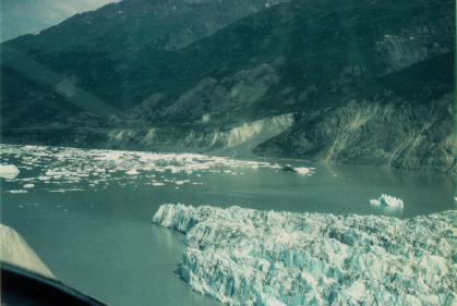
| Inner Lake George |
After circling the calving surface a few times, we flew up the Prince George Glacier and approached a pass beyond which was Prince William Sound.
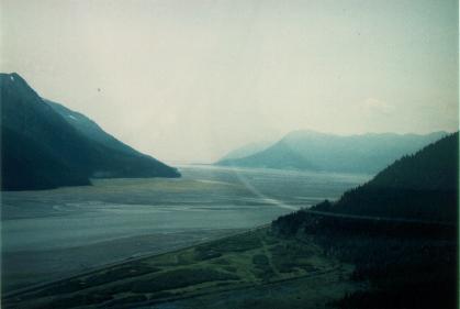 |
| Turnagain Arm |
After the flight ended, I continued up Turnagain Arm toward its very tip, the location of a town, a glacier, and a lake all named Portage. Several stretches of the highway sport a head-on view of the glacier, which calves off into the lake. On the shore of the lake near the outlet is a very good visitor center which has many glacier-related exhibits and a 20-minute film.
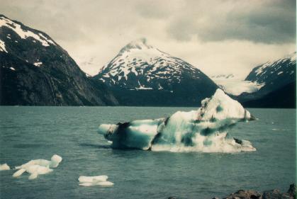 |
| Portage Lake with icebergs |
Another hour or so of driving brought me to a campground where I was to spend the next two nights. Its location was optimal: not too far from Kenai Fjords, where I was to hike tomorrow, and not too far back to Anchorage where I had to catch a flight to Katmai the following day.
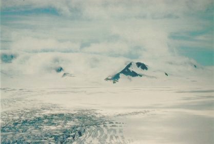 |
| Harding Icefield |
At the end of the hike I looped around on a self-guided trail that proceeds through the various levels of development of an ecosystem when terrain first becomes available therefor (e.g. when a glacier retreats or a fire clears vegetation). Fireweed is usually the first to arrive (which is why it is so named), followed later by cottonwood and finally by a coniferous forest, which remains indefinitely until the next catastrophe.
I proceeded to Seward, which, despite some tips from my Lonely Planet travel guide, didn't have much of interest. There was a Kenai Fjords visitor center with a few exhibits on the Exxon Valdez oil spill in 1989. The town was devastated on March 27, 1964, when the most powerful earthquake in recorded history struck Prince William Sound. The town was rebuilt, and no evidence of that disaster remains today except that the airport was relocated. I spent a little while browsing in some gift shops. Later I called my folks and my good friend Adam Helman. Finally I headed back to camp.
 Continue to
Part 4
Continue to
Part 4 Back to
Part 2
Back to
Part 2 Back to
the introduction
Back to
the introduction