Denali National Park
The van carrying me and two other passengers southbound approached the
Alaska Range along the George Parks Highway. Though mostly clear, the
weather was still too cloudy and hazy to see Denali. For a while the road ran parallel to
the Nenana River, which is exceedingly muddy and silty because of the
glaciers above it. As a glacier creeps downhill, it grinds and abrades the
underlying rock and soil into a very fine silt, called glacial flour, which
clouds the streams running from the terminus of the glacier. In the Alaska
Range this happens to such a great extent that the water is literally as
opaque as coffee. If you stick your finger into it, you cannot see an
eighth of an inch below the surface. The water is far muddier than that
running from the glaciers in the Cascade Range of the northwest. As we
approached the vicinity of Denali National Park, the many hotels and buses
made it easy to believe that the park is Alaska's busiest tourist
destination at some 800,000 people per year, most of which come between May
and September. By contrast, Gates of the Arctic, where I had been two days
earlier, gets a mere 4000 visits per year.
The van driver dropped me off at Morino campground, which is restricted to campers not travelling with a private vehicle. After setting up camp here, I proceeded to the visitor center where I verified my shuttle pass for the next day, checked out the gift shop, and spent a while in the "backcountry simulator", which is a small room in which interactive video about backcountry travel is shown. Here I learned many tips and tricks about stream crossings, a topic about which I could have used more knowledge in my Gates of the Arctic hike. The information I gleaned here proved useful later in the trip.
The rest of the day was taken up by a hike on the Mount Healy Overlook Trail, which climbs 1700 feet up the southeast slope of Mount Healy, or so said all of the sources of information I had on the trail. When I completed the short but steep hike to the overlook point, I found that the trail continued beyond this point toward the summit itself. So I continued to see how far it would go. The trail continued along the very crest of a grassy ridge and then threaded its way up some sharp rock pinnacles. By this time my altimeter showed that I had gained some 2500 feet in elevation. Ahead loomed the summit, which would be a scree and boulder scramble, mostly on a ridge, to climb the remaining 1500 feet. Then I thought I saw a trail on the ridge high above, and when I whipped out my binoculars to get a better look, I confirmed that yes, it was a trail, probably this one, leading to the summit. I now had a tough decision: not knowing in advance that the trail went all the way, I had not planned to climb Mount Healy, yet I sorely wanted to do so. What was originally planned as a 1700 foot climb could become a 4000+ foot climb. Some clouds were building overhead, and although I heard no thunder nor saw any lightning, there was a sprinkle of rain and it looked ominous enough to become a thunderstorm. After scrambling a little farther on the ridge, I saw that the trail gave out when the ridge dropped down to a saddle before joining another ridge. There was no sign of any trail other than the distant one much higher up. I finally "took the hint" and decided not to continue. Though I'm confident that a climb all the way to the summit of Mount Healy would have been well within my capability (something I did not suspect after looking at a topographical map when planning the trip), a pinnacled ridge is no place to be in an electrical storm, and the goal of the trip was not necessarily to climb mountains.
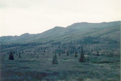
|
| Taiga |
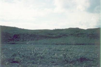
Wildlife, though not plentiful, was present. The inventory I caught sight of included two caribou, two herds of Dall sheep (both high on hillsides far away), and two sleeping bears. Amongst intermittent tundra and taiga the park road climbs and descends through several passes and valleys and includes many views of glacier-clad peaks along the backbone of the Alaska Range. Mount McKinley was never visible because of the heavy cloud cover. Some of the valleys are wall-to-wall gravel bars crossed by dozens of channels which typify the rivers of the area. The major ones are the Teklanika, the Toklat, and finally the Thorofare, of which there is a sweeping view from which for me was the endpoint of the bus ride: Eielson Visitor Center.
On a clear day, Eielson sports a sweeping view of North America's highest peak; although the rain had stopped and blue sky was visible through breaks in the clouds, that was not to be the case now. Behind the visitor center was a 500 foot downhill slope to the broad gravel bar over which ran the channels of the Thoroughfare River.
 |
| Muldrow Glacier terminus |
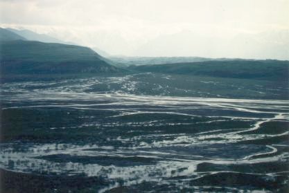 |
| Thorofare River |
The next day, after a final visit to the main visitor center, I boarded the Alaska Railroad for the 4-hour ride to Talkeetna. The Alaska Railroad is neither fast nor inexpensive, but has become a classical way to travel in Alaska. It is famous for its glass-domed cars with views in all directions and is used mainly by tourists who want to take a while to enjoy Alaska scenery. An important part of Alaskana, I would rate it the second most authentic way to travel in Alaska after the bush plane. During the ride I got my first glimpse of the very summit of Denali, which briefly poked up above a scattered layer of cumulus clouds.
Talkeetna
The first thing I did upon arrival to Talkeetna was head for K2 aviation,
where I was to go flightseeing around Denali. This quarter-mile walk turned out to
be quite strenuous; I took frequent rests because I had to carry the
combined weight of my backpack, daypack, and duffel bag- about 80 pounds
total. Because the weather was partly cloudy, it wasn't possible to do the
"grand tour" (which goes up the Kahiltna Glacier, around the far side of the
mountain by the Wickersham Wall, and back down the Ruth Glacier), which was
the flight I originally wanted to do. However, there were two other people
waiting to fly to see the Ruth Glacier and land on it. After some
negotiating, K2 put us all together on the same flight which gave us more
than any one of us had bargained for: a visit to the Kahiltna and Ruth
Glaciers with a landing on the latter.
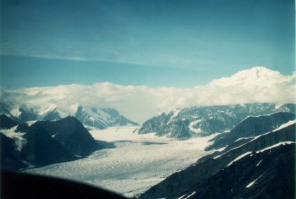 |
| Denali (Mount McKinley) and the Kahiltna Glacier |
An exciting and slightly harrowing flight close to some jagged peaks and through some passes brought us to the next main feature of the flight: the Great Gorge and the Ruth Amphitheater.
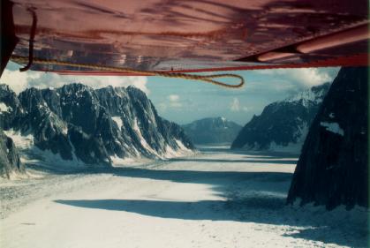 |
| The Ruth Glacier and the Great Gorge |
Back in Talkeetna, I endured yet another gruelling trudge with all of my gear to the town's public campground near the river. I spent most of the next day strolling around Talkeetna. Despite its small size (seasonal variation from 300 to 600 residents), it has quite a few points of interest. The historical museum has a 12 foot square scale model of Mount McKinley, showing the location of the major subpeaks, ridges, glaciers, and climbing routes. Because most climbers on the mountain fly to their starting points from Talkeetna, not the park itself, the climbing ranger station is here. The Talkeetna Cemetery has two points of interest: the grave of Don Sheldon, probably the most famous Alaska bush pilot of all time, and the climber's memorial, a simple board with a list of the names and ages of all climbers who have died on the Denali Massif. The families and friends of a few of these unfortunate climbers have erected individual memorials on their behalf on a few neighboring sites.
Exactly 24 hours after arriving in Talkeetna, I boarded the Alaska Railroad once again for the leg south to Anchorage. (The railroad runs the exact same schedule every day during the summer). The first half of the 3½-hour ride didn't have much to offer in terms of scenery, but as the train approached Anchorage, there were some good views of the Chugach Range, particularly Pioneer Peak and Goat Mountain. The ride ended in Anchorage shortly after 8 P.M. and was followed by a taxi ride to the airport to pick up my rental car. Although the outlying areas of Anchorage contain many visitor points of interest, the city itself is typical American urbania, so I settled for a spaghetti dinner at Pizza Hut, after which I drove several miles out of town to find a place to camp for the night. I ended up doing so at the end of a sparsely developed residential street near Eagle River, a suburb of Anchorage. As the rental car was a small station wagon, I folded down the back seat and found enough room to sleep in the back of the vehicle with my legs only slightly bent. It was the only night of the entire trip that I did not spend in my tent.
 Continue to
Part 3
Continue to
Part 3 Back to
Part 1
Back to
Part 1 Back to
the introduction
Back to
the introduction